


The Chalet Buvette de Caillet Hiking Circuit
A half-day hike that begins and ends in Chamonix centre
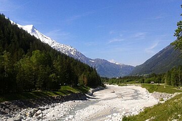
It’s been such a beautiful week here in Chamonix that it was a crime not to go exploring, so we headed off to the Caillets chalet on the way up to the Mer de Glace.
Setting off from the centre of Chamonix simply follow the river east (direction Argentiere) alongside the sports centre, past the tennis courts and through the Bois du Bouchet. Follow the trail to the road and take the underpass that pops out beside the Hotel Arveyron, keep left of the river until you come to the wide open area known as the “Desert Blanc”. If all you want is a short ramble with fantastic scenery then this area is perfect with dense forest on either side, towering peaks in every direction and a glacial river roaring straight through the middle - if you’re lucky you might also get to see the mountain rescue patrol taking off from the helipad. At the far end you’ll come to the biathlon shooting range, take the bridge to the right and carry on round to the right on the other side.
You’ll soon come to a hiking sign showing the way to Caillet, Rochers des Mottets and Montenvers Mer de Glace. Follow the path up into the cool scented pine forest that winds up surprisingly quickly above the valley. It’s not massively steep but it is fairly relentless, with barely any flat sections, so it’s not long at all before you’re looking down on aerial views of Chamonix and across to a sweeping panorama of the Brevent-Flegere side of the valley.
The forest is lush with thick green foliage and masses of wildflowers at the moment, wafting fresh invigorating scents into the air. Its not been so long since this area was announced as “out of bounds” by the Compagnie du Mont Blanc for being still at risk of snow slides and rockfalls; its amazing what a difference a couple of weeks of sunshine can make though and the paths are all now clear and perfectly passable.
The higher you climb, the less dense the forest becomes, affording wonderful views of the valley and the snowcapped peaks beyond. After about an hour of climbing the footpath will cross a 4x4 track where you can choose to turn right to Chamonix, straight on to Caillet or left to Montenvers via the Mottets buvette - a charming little mountain shack serving refreshments beside a stream.
I pressed on up to Caillet, which was only another 15 minutes or so along an idyllic path lined with fluffy white flowers (botany not my strong point, sorry) and paved with lots of gnarled old tree roots.
Caillet also has a refreshment point in the shape of a pretty wooden chalet perched precariously on the edge of the mountain, the terrace looming out over a steep precipice. It’s worth taking your life in your hands for the view though, and they do a decent slice of fruit tart as well.
From here you can either continue on up to Montenvers, from where you can take the train back down to the valley, or do as I did and follow the trail back down to Chamonix. Steep in places and littered with rocks, you may find hiking poles useful here, but there’s nothing too technical to worry about and it is a popular trail running route with lots of nice little twists and turns along the way.
After crossing the railway track you continue on the marked route back down to Chamonix where the path eventually spits you out onto what is a ski piste in the winter at Les Planards. Don’t panic if you hear screaming, it’ll most likely be coming from the toboggan ride that loops around the meadow - in the summer the ski area is transformed into a fun park. There is also a restaurant with a big sunny terrace if you fancy rewarding yourself with an ice cream on the way home.
This walk takes around 3 hours at a fairly leisurely pace and offers a number of variations along the way, if you wish to extend it or cut it short. The distance is approximately 10km.